NBIS undertakes a wide range of project work both alone and with partners. See below for a summary of current and recent projects undertaken. We are always interested in getting involved in new projects. If you have a project or a project idea you would like us to consider please email nbis@norfolk.gov.uk.
Current Projects....updating soon
Ongoing Projects
Bid-rex (Biodiversity Data Regional Exchange)
BID-REX is an Interreg Europe funded project focussing on better utilisation of biodiversity data in the delivery of policy. The project will develop an interactive interregional partnership to explore and exchange best practices through identifying information needs for decision makers, matching information to needs, improving data flows and capacity building for decision-makers and data providers.
What will we be doing?
Norfolk County Council and the University of East Anglia are delivering the project in the UK and will build on recent work such as the Breckland and Broads Biodiversity Audits, the Norfolk Living Map and the Norfolk Species Surveillance Network. We will work with data users and providers to assess data needs of decision-makers and the way in which these are met, high-light examples of best practice, assess future needs and ways to access data, focus on the use of added-value data such as opportunity maps and ecological network models.
A Red Data Book for Norfolk
Working in partnership with the Norfolk and Norwich Naturalists' Society and Norfolk Wildlife Trust, this project aims to create an online Red Data Book for Norfolk that is readily accessible and easy to update.
The first species to be added will be the 'Notable Ninety' species picked by the Norfolk Wildlife Trust as being particularly special to Norfolk. The County Recorders will then be given access to create and update pages for their speciality species.
While many of the species are likely to be designated nationally for their rarity, the Norfolk Red Data Book aims to highlight species that are particularly important in Norfolk, so this will not always be the case.
The Red Data Book is being created through a digital tool called Scratchpads, and the work so far has been done by an NBIS volunteer. Created by the Natural History Museum, Scratchpads are designed to broadcast biodiversity data online. Once more complete, the Norfolk Red Data Book will be published and be made accessible via the NBIS and Norfolk and Norwich Naturalists' Society websites.
The current draft Norfolk Red Data Book can be accessed at http://reddatabook.myspecies.info/
Recent Projects
The Ethics of Invertebrate Recording in Norfolk
NBIS have written a paper on the ethics of invertebrate recording in Norfolk, to be published in an upcoming edition of the Transactions of the Norfolk and Norwich Naturalists’ Society.
The paper is a result of the skills workshops and volunteer training events organised by NBIS in the Brecks as part of the Breaking New Ground ‘Wildlife Recorders of Tomorrow’ project. These workshops highlighted the issue of volunteers not being comfortable with, or not being aware of, the issues regarding the ethics of killing specimens as part of invertebrate recording.
The paper uses surveys of ‘Wildlife Recorders of Tomorrow’ volunteers, invertebrate County Recorders and national entomologist experts including Matt Shardlow (CEO of Buglife) and author Steven Falk, all undertaken during the Breaking New Ground project. A literature review on the ethics of killing specimens and the debate regarding invertebrate sentience was also conducted.
Arguments for and against killing specimens are presented and recommendations for future citizen science projects and general invertebrate surveying in Norfolk are presented.
River Hun State of the Environment Report
In March 2019, NBIS compiled a State of the Environment Report for an area surrounding the River Hun in north-west Norfolk for the Norfolk Coast Partnership.
The River Hun is a short chalk stream that runs just 6km from its source in Hunstanton Park to where it meets the North Sea at Holme Dunes National Nature Reserve. Covering an area of 3.82km2 adjacent to the river the report explains the geological features, flora and fauna that make the River Hun area an outstanding environment with national and international recognition and protection. These designations reflect the fact that the area has more valuable and diverse habitats than most other similarly sized areas which includes reed beds, sand dunes, saline lagoons and a multitude of other habitats
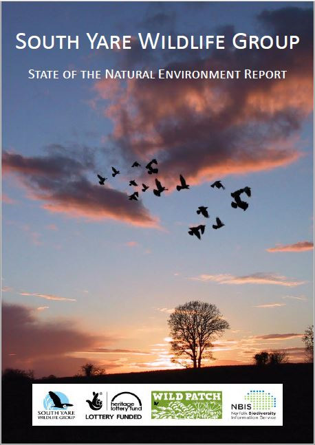
South Yare Wildlife Group State of the Environment Report
South Yare Wildlife Group commissioned NBIS to write a State of the Environment Report for their area. The report covers topics such as landscape and geodiversity, protected sites, habitats and land-use, species, water quality and local action groups. The report was launched at one of the group’s evening meetings and copies provided
to members.
Brecks ID Guides
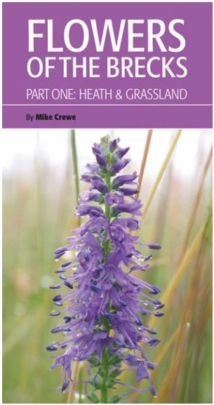
NBIS, along with several other local organisations, including The Breckland Society (www.brecsoc.org.uk), British Trust for Ornithology (BTO) (www.bto.org), Suffoik Naturalists’ Society (www.sns.org.uk) and the Norfolk and Norwich Naturalists’ Society (www.nnns.org.uk), have come together to deliver a new series of Brecks Wildlife Guides, the first two of which were published in early 2018.
It is hoped that these affordable and informative books will introduce new audiences to the area’s rich wildlife.
Birds of the Brecks was authored by Su Gough, whose experience in teaching people how to identify birds has helped to deliver a highly accessible book.
Flowers of the Brecks: Part One – Heath & Grassland was authored by Mike Crewe, a keen botanist with an expert knowledge of the region’s
flora.
NBIS has put considerable effort in the last few years into helping to improve the wildlife identification (ID) skills in the Brecks. This work has helped us recognise how vital it is for beginners, visitors to the area and families learning together with their children, to have access to an affordable easy-to-use ID guide that helps you make that identification and tells you how to record that wildlife sighting properly - this is the gap that these Brecks guides fill.
The guides are available to buy now.
Orchards East - Mapping Norfolk’s Traditional Orchards
Orchard’s East is a three year project covering six counties in the East of England, including Norfolk. Funded by the Heritage Lottery Fund and based at UEA it is devoted to discovering and understanding the past, present and future of orchards in Eastern England.
Working with hundreds of new volunteers, the project will survey and record old orchard sites across the region.
NBIS has been involved in mapping historic orchards in Norfolk, as they provide the best evidence of Traditional Orchard habitat locations before large scale losses and land use change occurred, especially post WWII. These maps help target areas for detailed survey to determine if the orchards still exist, their current extent and condition and whether or not they are currently being managed appropriately.
OS 6 and 25 inch maps (1879 - 1943) were used for digitising the historic orchards in Norfolk. Orchard polygons were either copied, pasted and edited from OS MasterMap or digitised by hand using the OS 6 inch or other OS base mapping.
252 5km grid squares were scanned through to identify orchards, with over 1387 orchards digitised. Commercial and private orchards were mapped.
Parish maps were then produced to be included in survey packs for volunteer surveyors to refer to on the ground. This work continues into 2018
-19.
Find out more about the Orchards East Project at https://www.uea.ac.uk/orchards-east/home
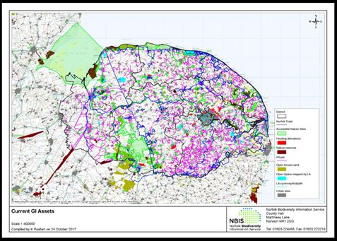
Norfolk Green Infrastructure Mapping Project
Commissioned by the Norfolk Strategic Planning Officer Group, this project
aimed to:
- Make the ‘connections’ between green infrastructure (GI) and growth, providing the Local Planning Authorities with a deliverable approach to addressing GI matters to enable and support growth
- Map the GI network of Norfolk, maximising the benefits it brings to the communities of Norfolk
- Identify deficiencies in GI provision
- Identify opportunities for enhancements
Mapping was undertaken by NBIS and consultants Environment Systems. Maps produced included GI Access Asset Mapping (including Norfolk Trails, public
rights of way, open access land and accessible nature reserves), GI Network Mapping (assessing the potential links between existing semi-natural habitats and
protected sites, and producing a series of proposed GI corridors) and Ecological Network and Opportunity Mapping (for grassland/ heathland, woodland and wetland habitats, and combined).
The GI Access Asset map was used as the basis for assessing potential GI deficiency in the County, using the Natural England Accessible Natural Greenspace
Standards (ANGSt) guidelines and the Woodland Trust Woodland Access Standard.
Additionally, two maps were produced relating to natural flood management in the county.
Breaking New Ground - Wildlife Recorders of Tomorrow
The Brecks is an important area for wildlife both in a UK and international context. However many of the species records come from a few well recorded designated sites, with recording often done on an ad hoc basis. This means that it is often difficult to detect changes in the biodiversity of the area. There is a need for wider recording of the Brecks area and a structured programme of species surveillance and monitoring.
In order to address this NBIS has been involved in an HLF funding project called Breaking New Ground, which was an overarching theme for several smaller projects, aimed at increasing public awareness in the heritage and landscape of the Brecks. As part of this project NBIS led on the Wildlife Recorders of Tomorrow Project which focused on improving skills and involvement in wildlife recording.
Progress of this project has previously been reported on since its start up at the end on 2014/ beginning of 2015. This report now summarises successes of the project as a whole following its completion in June 2017.
In total 785 people volunteered as part of the project and many more were engaged in the project through bioblitz and other public events. This massively exceeded the project target of 60 and came from across the skills spectrum from those new to recording to wildlife experts . In total 974 days were volunteered to the project time which is worth £133, 031. Thank-you very much to all involved.
As a result of this project records were received from 384 sites, 23 which were monitored and 361 which were recorded for at least one taxonomic group. This again exceeds targets to monitor 10 sites and record at 40. In total a massive 32,210 new records have been generated and greatly add to our understanding of wildlife in the area.
As part of the project over 40 workshops, training days and talks have also been delivered to develop wildlife recording skills and encourage interest in biological recording. In addition 4 successful bioblitz's took place at Brandon (October 2015 and July 2016), High Lodge (July 2016) and Little Ouse Headwaters (June 2016).
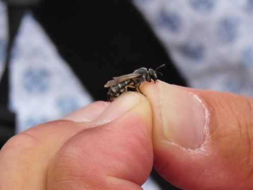
These events covered a wide range of topics including birds, mammals, plants, fungi and a number of invertebrate groups including bees, hoverflies and bug sorting marathons. One of the very exciting finds of the July weekend was the Ashy Furrow-bee (Lasioglossum sexnotatum, pictured) a very rare bee, previously only seen once in Norfolk in the 1980s, was found in St Leonards Churchyard in Mundford!
The feedback from attendees was overwhelmingly positive.
The project was picked up well in local media which included promotion of our bee workshop in an EDP article by Mark Cocker and an article on the Lunar Yellow underwing Workshop in the Bury Free Press. Features on Radio Norfolk and Brecks FM also help promoted workshop's, as did blogs and articles calling for volunteers published by Norfolk Wildlife Trust
EODIP5
Earth Observation Data Integration project (EODIP5) was a short project, led by the British Trust for Ornithology (BTO), to appraise the potential for volunteers and communities to become habitat validators and to look at open source technology to support this. This project neatly followed on from the results of MEOW Phase 2 (Making Earth Observation Work: http://jncc.defra.gov.uk/page-6279), an initiative to develop new land cover maps, or "Living Maps", with a special focus on priority semi-natural habitats which have been identified as most threatened and requiring conservation action.
The first such "Living Map" was developed for Norfolk, and because it has involved complex analyses of large datasets it is necessary to identify where errors and uncertainties are most likely to arise, and to consider methods for validating the map.
Possible methods for validation could include a desk-based approach where volunteers are able to check the Living Map against other data sources, such as earth observation imagery or photographs, or a field-based approach, where observers visit certain points, grid squares or habitat patches to validate the habitat in the field.
Stakeholder interviews were undertaken by NBIS to determine how a volunteer community of habitat validators might best be set up and promoted to. NBIS also acted in an advisory role to the steering group of this project. Survey methods and techniques, communications and a technological appraisal for a possible smartphone app and/or website platforms are being undertaken by BTO. A report will be available soon.
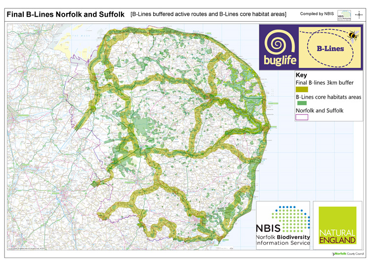
B-Lines
B-Lines was a project run by the charity Buglife which aimed to map key insect pollinator dispersal pathways (B-Lines) at a county or regional level, then link these with B-Lines mapped in adjacent counties or regions. The mapping used basic connectivity modelling to identify the pathways. It was designed to be both simple and pragmatic, using existing Green Infrastructure and biodiversity mapping alongside local stakeholder and partnership knowledge to refine and confirm priorities.
NBIS were contracted by Buglife to draft the B-Lines for Norfolk and Suffolk, to prepare the final maps, present them to the stakeholders and to map the revised corridors following a workshop. For more information on this project please click here.
Data Digitisation
NBIS acquired funding from the Government's Release of Data Fund via the National Biodiversity Network in order to digitise the paper habitat maps drawn as part of the surveys of County Wildlife Sites in Norfolk from 1985 - present, as well as digitising the species records from those initial surveys. In total, approximately 5210 habitat polygons have been mapped on GIS and 79908 species records digitised (including 2560 notable species).
In a second part of the project, extra funding was secured to digitise the paper Phase 1 habitat map for Norfolk from 1983-85. Once complete, this can be compared with our recent remote sensing habitat map. Over 8245 habitat polygon have been mapped.